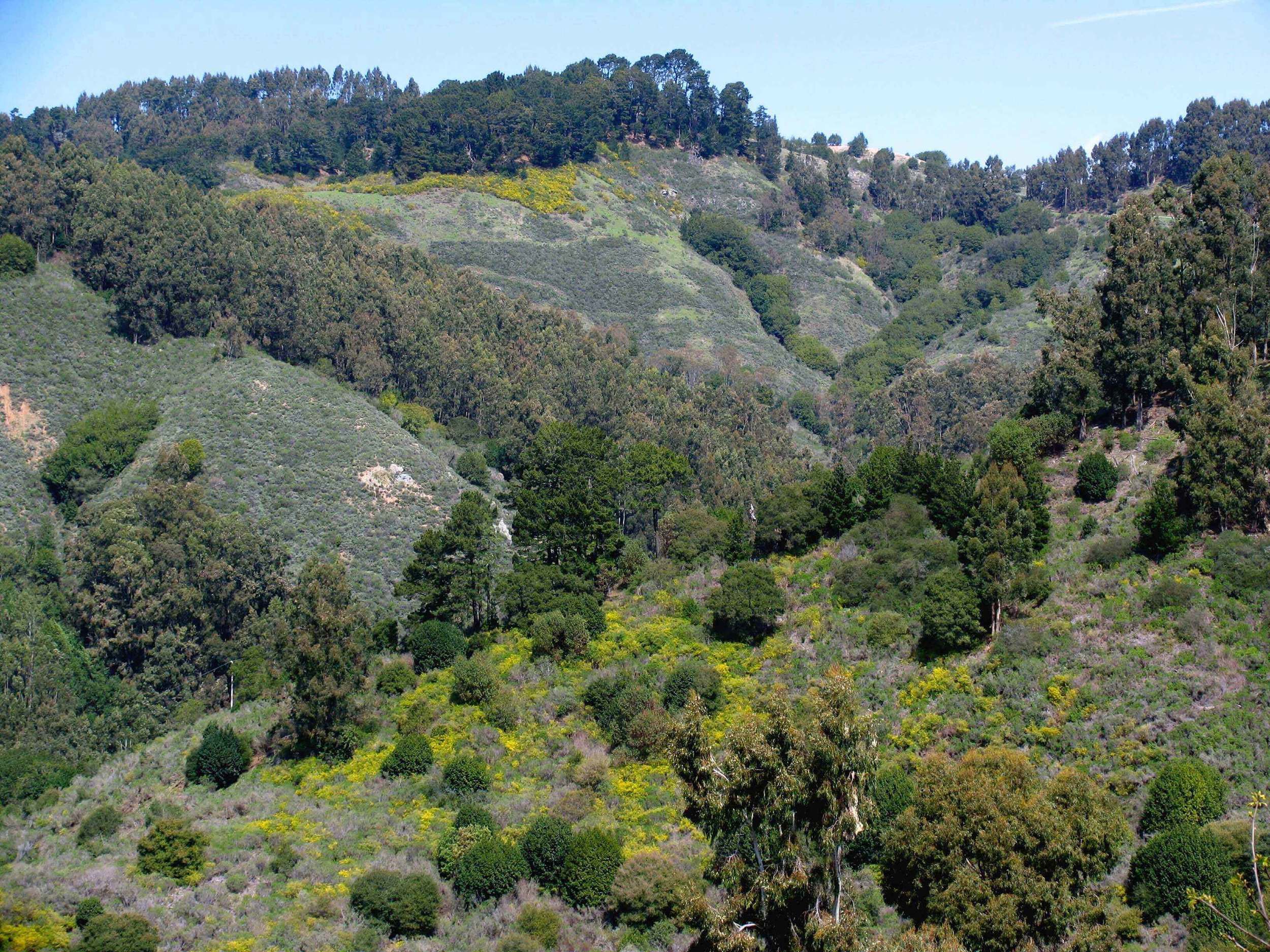
NATURAL HISTORY: Claremont Canyon is the largest, relatively undeveloped canyon on the western slope of the Oakland/Berkeley hills. Most of the canyon's 500-acre watershed is owned by public agencies, the East Bay Regional Park District, the University of California, the East Bay Municipal Utility District (east of Grizzly Peak Boulevard) and the City of Oakland (Garber Park), with one fifth held in private hands.
CULTURAL HISTORY: The Claremont Canyon landscape and its uses have changed dramatically over the last century. From the 1800's through the first few decades of the 20th century, the East Bay Hills were primarily grasslands with trees and brush growing only in canyon draws.

Much of Gwin Canyon, a tributary on the south side of Claremont Canyon, was planted with Monterey Pines (Pinus radiata), a widely established practice in the hills to beautify the land for housing developments in the early Twentieth Century. That these trees were fast-growing tinder in the landscape became evident after every subsequent hill-area wildfire.
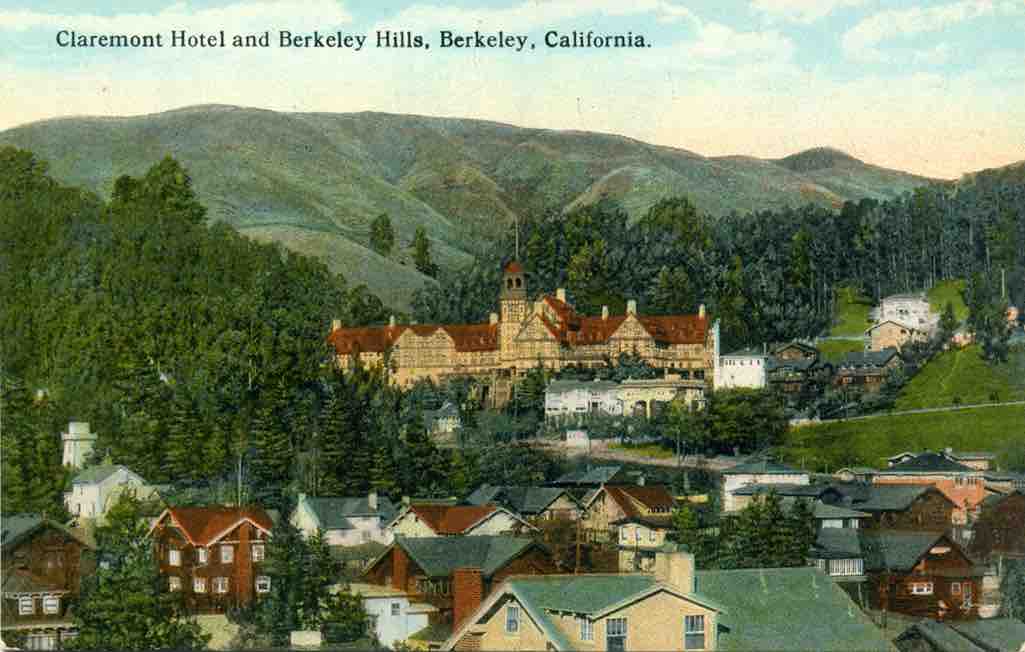
In 1910, Frank Haven, owner of the Claremont Hotel, planted Eucalyptus on the Claremont Canyon watershed land that provided water for the hotel grounds. Around the same time, Eucalyptus were planted in pockets throughout the Canyon. This species was thought at that time to be a valuable lumber source, but, once its defects were discovered, it was too late it had become entrenched in the landscape. In addition to squeezing out native biodiversity, it has been found to be highly flammable. Firebrands from burning Eucalyptus in Australia have been known to spread fires far and wide from the initial fire. [Merwin, Miles, California Eucalyptus Grower]
During the winter of 1972-73 many of the Eucalyptus froze. When assumed dead, trees on UC land were logged by the landowners. Redwoods were then planted in the upper Canyon, with the help of the Rotary Club, but were soon in competition with the fast recovering Eucalyptus. This part of the Canyon is now thick with second growth Eucalyptus and an understory of mostly native bay trees. The combination of these unmaintained Eucalyptus groves with their impenetrable understory represents a worst possible case of ladder fuels that could allow a ground ignition to become a crown fire.
Up to the early 1960s, much of the south-facing side of Claremont Canyon was grazed by ever-diminishing numbers of cattle and horses. Since then—in the absence of grazing , controlled burns, or other forms of management—most all the grasslands have converted to brush and forest. These brushlands are predominantly coyote brush (Baccharis pilularis, a native shrub prone to fire), poison oak, and French broom. In Claremont Canyon and much of the East Bay hills, French broom, an aggressive exotic weed shrub, has been spreading noticeably every year since the 1980's. The uninterrupted acres of Broom and native chaparral that now cover the south-facing slopes of Claremont Canyon and most of Gwin Canyon are a high intensity fire hazard. Under Diablo-wind conditions, these continuous fuel loads combined with steep, inaccessible slopes make large fires in Claremont Canyon unfightable from the ground.
THOROUGHFARES AND TRAILS: In 1858, the transcontinental telegraph cable between the west and east coasts was strung through Claremont Canyon. Not long after, a road was built along the telegraph line. What is now Claremont Ave running from Berkeley along the canyon bottom and over into Contra Costa County, became the primary route for east-west horse and wagon travel in the central East Bay hills. In 1860 -61, the Pony Express brought news from the east coast through Orinda, up Fish Ranch Road and down Claremont Canyon on its way to San Francisco by ferry. From the late 1800's into the early 1900's, commercial development in the Canyon included a hotel and saloon rest stop.
Once the first tunnel connecting the west and east sides of the hill was built in 1903, the road reverted to a trail used for equestrian outings or for driving cattle from the east side of the hills, down Ashby Ave. to the slaughterhouses in Berkeley. In 1929, the trail was widened, paved, and reestablished as a road, this time for cars.
The University of California acquired roughly 150 acres of the upper part of the Canyon from the local water district in 1961 with no plan to develop it in any way. In the 1970's and 80's a neighborhood group, the Friends of Claremont Canyon, spurred the EBRPD's purchase of private parcels amounting to 208 acres spanning both sides of the Canyon. This land, on the verge of being developed into housing, thus became the Claremont Canyon Regional Preserve. Both UC and the EBRPD intended minimal human intrusion or interference with natural processes or habitats on their land in the Canyon. UC designated theirs an "Ecological Study Area" while EBRPD has done little to encourage hikers. A trail system for the preserve was proposed in 1973, approved and adopted by the Park Board in 1985, but the system was never completed and the main fire/hiking trail is minimally kept up.
The City of Oakland's 13-acre John Garber Park is located just up the Canyon from the Claremont Hotel on the southern side. In its heyday during the 1920's, this small park, complete with trails and picnic areas, lay close to the mouth of a virtually wild canyon since all the automobile traffic had been diverted through the tunnel later named the Caldecott. Although it was neglected for years, it is now lovingly maintained by volunteers of the Garber Park Stewards. It has some of the largest trees in the Canyon, a mature native oak/bay forest with scattered maples and buckeye, wedged between residential streets.
WILDFIRES IN THE CANYON: In the 20th century, fourteen major fires have passed through areas of the East Bay Hills, many driven by the late summer-fall northeasterly Diablo winds. The 1991 Oakland hills fire ranks first as California's largest home loss from wildfire, with over 2000 homes destroyed, and the 1923 Berkeley Fire ranks fourth. Both fires burned into Claremont Canyon. Its south-facing slope was the southern extent of the 1923 fire. (Firemen at the Hemphill residence in the canyon bottom just up Claremont Ave. from Gelston Drive, lit a backfire to save the house from flames descending from the ridge [conversation with Tappy Marron, 2001].) The northern edge of the 1991 fire was on its north-facing slope, in particular Gwin Canyon. This side canyon has burned repeatedly in 1946, 1970, and 1991.
These prescient words written four years before the 1991 fire may well apply to Claremont Canyon today:
In just over a century many ecosystems in the Bay Area were transformed. Exotics supplanted native vegetation and people began to take up residence in what were previously natural environments. With both fire and grazing disqualified as participants in the game of ecological balance, much of the wildland in the Oakland and Berkeley hills began what some think is a slow devolution. "Our grassland has broken down to the point where it's just weeds," claims David Amme, a botanist, native plant expert. "When you take fire and grazing out of the ecosystem, the ecosystem goes into a long sort of self-destruct, building debris and fuel. That's why I can say with no qualms at all that there will be a fire. There is no 'If there is a fire, we'll come and put it out.' There will be a fire, and it will take out everything."[East Bay Express article 8/87]
The magnitude of future fires in Claremont Canyon will be determined by fuel loads, weather conditions (especially relative humidity and wind), topography, and the ability of fire fighters to quell a fire early. Coordinated professional wildland fire fighting capabilities have improved in the East Bay Hills since the 1991 fire, and the addition of an Oakland Fire Station at Amito and Gravatt above the Canyon in 1998 is a notable advance. But fire fighters and equipment in steep canyons simply cannot confront fires where flame fronts move with great heat, height, and speed. Air attacks might be helpful, but if much of the Canyon is aflame and filled with smoke as in 1991, flying is dangerous, visibility severely reduced, and targets difficult to find.
SPARKING THE POTENTIAL FIRESTORM: Ignition without the presence of humans is unlikely since lightening strikes during dry weather are rare along coastal California (August 2020 was a notable exception). Before the arrival of European settlers, the indigenous people habitually started fires in native vegetation as part of their ongoing manipulation of the environment for more food, forage, or otherwise useful materials. Both animals and plants had a good chance of surviving these low-intensity wildland fires. Although settlers may also have set fires to increase rangeland productivity, fire suppression became accepted policy in the early 1900's, contributing to the current build-up of fuel and history of accidental fires.
Making Claremont Canyon completely firesafe is probably impossible and impractical, but improving the chance of successfully extinguishing an accidental ignition is a realistic goal. What might be an uneventful ignition in less extreme circumstances, may be the beginning of a conflagration given a relative humidity below 20%, winds above 10 mph, and enough fuel. The intent of the buffer zone we propose herein is to decrease the intensity of fire, slow its spread, and give firefighters an opportunity to make a stand.
Dry dead vegetation is potential fuel that will burn hotter and faster than live plant material. Annual vegetation, like most of our grasslands, dies in summer, but may be cut low to decrease the rate of spread. As brush, in particular Baccharis, grows old, interior branches die. Ladder fuels are flammable materials that allow a ground fire's rapid ascension into the crown of a tree. Crown fires are more difficult to fight than ground fires and travel faster over the topography.
Ignitions can happen from cigarettes, fireworks, or hot exhausts of cars parked over dry roadside vegetation. Reducing the fuel loads along roads both reduces the chance of ignitions and increases the possibility of firefighters' preventing a small fire from getting out of hand. If not engulfed in flames, roadsides, especially on ridgelines, are also strategic locations for fighting fires, as well as allowing safe evacuation routes.
Ignitions may happen near or in dwellings. The same buffer zone that protects a house from burning brushlands can protect against the spread of fire to a natural environment from fire originating in buildings or yards sparked by faulty electrical systems, downed electric lines, transformer failure, power tools, oily rags combustion, barbecue sparks, and similar accidents.
Thinning out dead and dry vegetation and reducing the density of flammable brush and ladder fuels within a 250 foot perimeter of roads and structures lessens the likelihood of a minimal spark becoming a raging blaze. The buffer zone width can shrink as the local features indicate. For instance, where Claremont Creek runs within this 250 foot zone, minimal cutting is warranted. Another area where the buffer zone could shrink to less than 50 feet of the road edge is along Grizzly Peak Blvd where a rich plant community of Oracle Oak, Big Leaf Maple, Hazelnut, Oceanspray, and Huckleberry grows. The 250 feet of managed vegetation implies periodic selective thinning or mowing of Baccharis, complete removal of French Broom, spring and summer mowing of annual grasses (first to reduce their seed bank and secondly to ensure a minimal fire hazard), limbing up and removal of ladder fuel below all trees.
Ideally this work would be done by hand crews, including loggers, trained in the local ecology so that they can discriminate between desirable and undesirable vegetation. Goat grazing, though popular with the general public, wreaks havoc on any desired vegetation unless painstakingly excluded from the enclosure. Also timing is critical. For instance, periodically grazing a site infested with annual weeds in the spring and early summer may discourage their spread by seed. When to bring in the goats and for how long must be based on careful monitoring of the condition of the site. Any grazing for vegetation management needs to consider first the benefit to the flora, then to the animals. Close attention to the variability of annual conditions is another key. Though more costly, flexibility based on expert monitoring must be written into any contract specifications.
The goal is to achieve an articulated vegetation profile that would look similar to a landscape that has been "managed" by a low-intensity prescribed burn. Appropriate parts of the canyon could be gradually restored to a low density oak savanna. As suggested by Prof. Radke's UCB students studying the issue of the fire hazard in Claremont Canyon several years ago, this vegetation type is associated with both a low fire intensity and a low rate of density increase. Ridgelines where fires can be battled by firefighting crews and equipment would be restored to perennial grassland, while the low points in the topography, the canyons and draws, would be vegetated with trees and brush. This fuelbreak of open yet diverse vegetation represents a transition from the thick untouched native chaparral and forest to the corridors and perimeters of the Canyon that people frequent. Maintenance of this buffer zone includes active monitoring for invasive species and their immediate removal, as well as appropriate collection of garbage and trash.
The details of a canyon-wide restoration plan have been worked out by a committee of Conservancy board members and expert consultants representing the major landowning entities: UC (Tom Klatt), EBRPD (Jerry Kent), and the state of California (Joe Engbeck). A document was produced called An Advocate Plan for Claremont Canyon. A GIS study of the Canyon was made to serve as a base for developing models of vegetation management that might transform the character of some areas while leaving others untouched. This plan incorporates a network of foot trails that will allow and encourage firsthand appreciation of the watershed. The long-term goals of fire hazard reduction and better public access can not be realized without the cooperative input of all the key players. But it is ultimately up to the concerned citizens to push for action.